उष्णकटिबन्धीय चक्रवात TROPICAL CYCLONES
उष्णकटिबन्धीय चक्रवात


(TROPICAL CYCLONES) सामान्यतः कर्क तथा मकर रेखाओं के मध्य स्थित क्षेत्र में उत्पन्न चक्रवातों को उष्ण कटिबंधीय चक्रवात कहते हैं। व्यापारिक हवाओं की पेटी में मुख्यतः महाद्वीपों के पूर्वी भागों में एवं उष्णकटिबन्धीय मानसून प्रदेशों में उत्पन्न एवं विकसित होने वाली सभी प्रकार के विक्षोभ उष्णकटिबन्धीय चक्रवातों की श्रेणी में आते हैं। इनको क्षेत्रवार विविध नामों से पुकारते हैं। जलवायु व मौसम विज्ञान के अध्ययन में इनका विशेष महत्व है। यह प्रभावित क्षेत्र में तेजी से उग्र रूप धारण करके उत्पात मचाते रहते हैं। शीतोष्ण चक्रवातों के समान इनमें समरूपता नहीं होती है।
सामान्य विशेषतायें-उष्ण कटिबंधीय चक्रवातों में कुछ ऐसी सामान्य विशेषतायें होती हैं, जिनके आधार पर उनको पहचाना जा सकता है
(i) इनके आकार में पर्याप्त अन्तर होता है। इनका व्यास 50 से 300 किमी. तक होता है।
(ii) इनकी गति में पर्याप्त भिन्नता पायी जाती है। कुछ 32 किमी. प्रति घण्टा की गति से भ्रमण करते है. तो कुछ 200 किमी. प्रति घण्टा से भी अधिक रफ्तार से बढ़ते हैं।
(iii) ये सागरों के ऊपर तीव्र गति से चलते हैं, किन्तु स्थल पर आते ही क्षीण पड़ जाते हैं। अतः महाद्वीपीय तटों को अधिक प्रभावित करते हैं।
(iv) इनके केन्द्र में वायुदाब बहुत कम होता है। इनकी समदाब रेखाओं की संख्या बहुत कम होने के कारण मानचित्र पर सरलता से प्रदर्शन नहीं हो सकता है।
(v) इनमें विभिन्न वातान नहीं पाये जाते हैं एवं तापमान सम्बन्धी भिन्नता भी नहीं होती है। (vi) प्रचण्ड गति तथा तूफानी स्वभाव के कारण ये अत्यन्त विनाशकारी होते हैं। (vii) उष्ण कटिबंधीय चक्रवात के प्रत्येक क्षेत्र में वर्षा होती है।
(viii) ये सदैव गतिशील नहीं रहते हैं, बल्कि कभी-कभी एक ही स्थान पर कई दिन तक स्थायी होकर भारी उत्पात मचाते हैं।
(ix) इनका भ्रमण पथ भिन्न-भिन्न क्षेत्रों में भिन्न होता है। ये सामान्यतः व्यापारिक पवनों के साथ पूर्व से पश्चिम की ओर अग्रसर होते हैं।
(x) उष्ण कटिबंधीय चक्रवात वर्ष के निश्चित समय खासकर ग्रीष्मकाल में ही आते हैं। शीतकाल में नहीं दिखायी देते हैं।
(xi) सभी उष्ण कटिबंधीय चक्रवात आवश्यक रूप से महासागरीय तल पर ही जन्म लेते हैं एवं रौद्र रूप धारण करते हैं। उष्ण कटिबन्धीय चक्रवातों की उत्पत्ति एवं विकास की अनुकूल दशाएं
व्यापारिक हवाओं की पेटी एवं विषुवत्रेखीय शान्त खण्ड का मिलन क्षेत्र उष्ण कटिबन्धीय चक्रवातों के विकास का आदर्श प्रदेश माना जाता है। यहां के शान्त समुद्री क्षेत्रों में स्थानीय संवहन के समय धोंकनी की भांति निरन्तर जल वाष्य ऊपर उठती है, अतः संवहन की आदर्श दशा होने पर इसमें तूफानी लक्षण आने लगते हैं। ऐसे ही स्थलों पर स्थानीय रूप से निरन्तर नमी का संतृप्त क्षेत्र बनने एवं वहां के ऊंचे तापमान
के सम्मिलित प्रभाव से तेजी से वायुदाब भी गिरता जाता है। इससे समदाब रेखाओं का ऐसा वृत्ताकार घेरा
के परिवर्तन काल अथवा वायु भार की पेटियों के उत्तर या दक्षिण में खिसकने के समय अधिक विकसित होते हैं। कई बार यह उत्पत्ति स्थल (सागर) पर कई दिनों तक स्थिर प्रायः रहकर अधिक शक्तिशाली रूप धारण
कर लेते हैं।
जाने पर
उष्ण कटिबंधीय चक्रवातों के प्रकार तीव्रता के आधार पर उष्ण कटिबंधीय चक्रवातों को तीन भागों में विभक्त किया जाता है
(1) उष्ण कटिबंधीय विक्षोभ (Tropical Disturbance)—यह क्षीण चक्रवात होते हैं। इनमें हवायें मंद गति से केन्द्र की ओर प्रवाहित होती है तथा यह मंद गति से ही आगे बढ़ते हैं। इनमें एक या दो घिरी हुई समदाब रेखायें होती हैं। भूमध्यरेखीय निम्न वायुदाब पेटी में मिलने वाले इन चक्रवातों को भूमध्यरेखीय गर्त (Equatorial trough) भी कहते हैं। इनमें हवायें पूरब से पश्चिम की ओर चलती हैं। इनका विस्तार बहुत व्यापक होता है। इनकी गति 10 से 25 किमी. प्रति घंटा होती है।
(2) उष्ण कटिबंधीय अवदाब (Tropical Depression)-छोटे आकार के उष्ण कटिबंधीय चक्रवात, जो कि एक से अधिक समदाब रेखाओं वाले होते हैं, को अवदाब कहते हैं। इनके अंदर हवायें 30-50 किमी. प्रति घण्टे के वेग से चलती हैं। इनकी दिशा तथा गति अनियमित होती है। जो चक्रवात भारत में बंगाल की खाड़ी के उत्तरी भाग में उत्पन्न होते हैं, उन्हें चक्रवात या साइक्लोन ही कहते हैं। आस्ट्रेलिया में उष्ण कटिबंधीय तूफान विली-विली के नाम से जाने जाते हैं। इन चक्रवातों से प्रभावित क्षेत्रों में भारी वर्षा होती है। जापान तथा चीन के दक्षिणी भागों को भी ये प्रभावित करते हैं।
(3) हरिकेन या टाइफून (Hurricane or Typhoon)—ये विस्तृत उष्ण कटिबंधीय चक्रवात होते हैं, जिनमें कई समदाब रेखायें होती हैं। इन्हें संयुक्त राज्य अमेरिका में हरिकेन तथा चीन में टाइफून कहते हैं। तीव्र दाब प्रवणता के कारण इनमें पवन बड़े वेग से केन्द्र की ओर चलती है। हवाओं की गति 120 से 200 किमी. तक होती है। इनका व्यास 160 से 640 किमी. तक हो सकता है। भूमध्य रेखा से दूर इनका आकार बढ़ता जाता है। हरिकेन के साथ 3 से 6 मीटर ऊंची सागरीय तरंगें उठती हैं, जो तटीय भागों में प्रवेश कर जन-धन को अपार हानि पहुंचाती है। इसमें तापमान सम्बन्धी अन्तर नहीं होने के कारण विभिन्न वातान नहीं पाये जाते हैं।
उष्ण कटिबंधीय चक्रवात में मौसम-उष्णकटिबन्धीय चक्रवात के विकास के लिए वायुदाब, जलवाष्प एवं तापमान तीनों ही आधार-स्तम्भ हैं। भीतर की ओर सघन न्यून वायुदाब, सागर तल पर निरन्तर वाष्पीकरण तथा गुप्त ऊष्मा के प्रभाव से सघन न्यून भार की दशा बने रहना एक-दूसरे से जुड़े हुए पहलू हैं। एक विकसित हरिकन या चक्रवाती तूफान की वाहरी समभार रेखा जहां 1,016 मिलीबार होती है वहीं भीतरी मध्यवर्ती समभार रेखा 950 मिलीवार तक ही रह जाती है। इससे कई बार स्थानीय रूप से संवहन के साथ पानी की धार भी ऊपर उटने लगती है। इसी कारण ऐसे उत्पाती चक्रवातों में भारी वर्षा के समय मरे हुए छोटे जीव भी पाये जाते हैं। सामान्यतः सतह पर उष्ण चक्रवातों के तापमान ऊंचे बने रहते हैं, जो कि यह 27° से 31° सेण्टीग्रेड के मध्य होते हैं। यह पश्चिमी द्वीप समूह एवं चीन सागर में सितम्बर में, बंगाल की खाड़ी में मानसून दशा के कारण दी वार मानसून से पूर्व (अप्रैल-मई) एवं मानसून के पश्चात् (अक्टूबर-नवम्बर) में आते हैं। बंगाल की खाड़ी से मानसून काल में भी उष्ण चक्रवात विकसित होते रहते हैं।
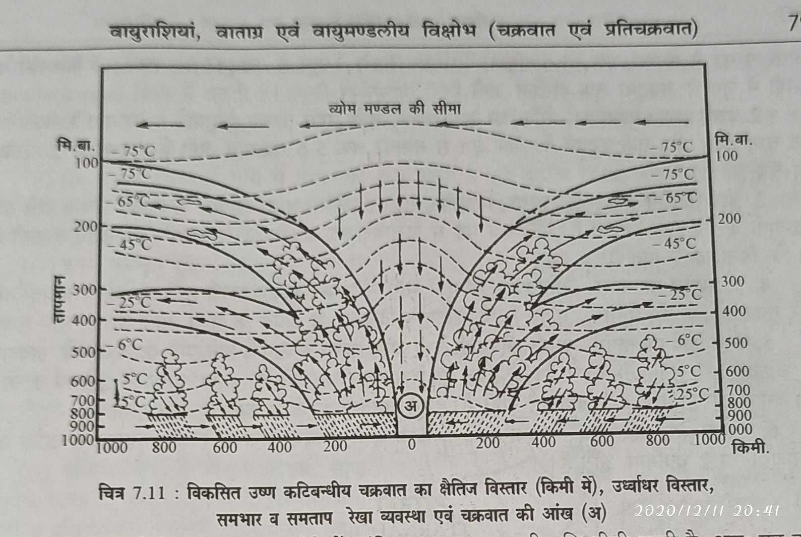
एक सुविकसित उष्णकटिबन्धीय चक्रवात का क्षैतिज विस्तार 400 किमी के आस-पास रहता है। लम्बे समय तक सागर पर रहने से यह रौद्र तूफान का रूप धारण कर लेता है। इसमें 6 से 10 किमी की ऊंचाई तक जल वाष्य एवं गुप्त ऊष्मा के प्रभाव से एवं संवाहनिक गति होने से निरन्तर गर्जन-तर्जन एवं वायु विक्षोभ बना रहता है। उष्ण चक्रवात आने से कुछ घण्टे पूर्व ही आकाश में निम्न पक्षाभ व मिश्रित मेघ बड़े आकार में फैल जाते हैं। 30 से 60 किमी प्रति घण्टा की गति से पवनें चलने लगती हैं। चक्रवात के आगमन के साथ ही साग वायुमण्डल घने व काले वर्षीले एवं ऊंचे कपासी मेघों से ढक जाता है। दिन में ही अंधेरा-सा हा है तथा भीषण मूसलाधार वर्षा प्रारंभ हो जाती है। वर्षा का सामान्य औसत 10-25 सेमी. होता है किन्तु कभी-कभी यह 75-100 सेमी, भी हो सकती है। तेज गति से झंझावात चलता है। चक्रवात के प्रवेश के साथ ही पवनों की गति 100 से 200 किमी या उससे भी अधिक हो जाती है। समुद्र में खड़े जहाज लंगर तोड़कर भटक जाते या डूब जाते हैं। भारी वर्षा एवं रौद्र गति से चलने वाली हवाएं मिलकर सागर तट के निकट के भागों व द्वीपों पर प्रलय मचा देते हैं। चूंकि उष्ण चक्रवात की गति धीमी रहती है, अतः यह उत्पात कई घण्टों तक भी रह सकता है। जब मध्यवर्ती भाग निकट पहुंचता है तो यकायक हवा चलना बन्द हो जाती है, क्योंकि यह केन्द्रीय भाग चक्रवात की आंख होती है। यहां पर वास्तव में पवनें नीचे उतरती हैं। इसी दबाव व प्रभाव से वर्षा व पवन गति को रोक लग जाती है। यह नीचे उतरने वाली पवनें समुद्री सतह पर पुनः तापमान बढ़ते ही वाष्पीकरण करके चक्रवात को सजीव या ताकतवर बना देती है।
'चक्रवात की आंख एक प्रकार का धोखा है' क्योंकि ऐसे समय में मानव सुखचैन की सांस लेने लगता है, वह समझता है कि चक्रवात चला गया। जबकि वास्तव में थोड़ी देर बाद वही रौद्र रूप लिए चक्रवात गर्जना व चमक के साथ दहाड़ने लगता है। मानव की असावधानी से ऐसे चक्रवात दुगुना व घातक प्रभाव डाल देते हैं। संयुक्त राज्य, दक्षिणी चीन, दक्षिणी जापान , बंगाल की खाड़ी के तट पर इससे भारी नुकसान होता रहता है। ऐसे चक्रवात मुख्य भूमि पर प्रवेश करने के पश्चात् शीघ्र कमजोर पड़ने लगते हैं। चक्रवातों के आगे निकल जाने पर बादल छंट जाते हैं तथा मौसम साफ हो जाता है।
उष्ण कटिबंधीय चक्रवातों का वितरण—उष्ण कटिबंधीय चक्रवात मुख्य रूप से 5° से 15° अक्षांशों के मध्य दोनों गोलार्डों में सागरों के ऊपर पाये जाते हैं, किन्तु इनका प्रभाव 30°-35° अक्षांशों तक देखने क. मिलता है। उष्ण कटिबंधीय प्रदेशों में चक्रवातों के छः प्रमुख क्षेत्र मिलते हैं, जहां इन्हें भिन्न-भिन्न नामों से जाना जाता है
1. उत्तरी अटलाण्टिक महासागर-अटलाण्टिक महासागर में 30° उत्तरी अक्षांश तक प्रतिवर्ष 7 चक्रवात आते हैं, जिनमें से आधे हरिकेन का रूप धारण कर लेते हैं। इनमें से (i) केप वर्डे द्वीप क्षेत्र में अगस्त तथा सितम्बर में, (ii) पश्चिमी द्वीप समूह के उत्तरी व पूर्वी भाग में जून से अक्टूबर तक, (iii) उत्तरी कैरेबियन सागर में मई से नवम्बर तक, (iv) दक्षिणी कैरेबियन सागर में जून से अक्टूबर तक तथा (v) मैक्सिको की खाड़ी में जून से अक्टूबर तक हरिकेन आते हैं।
2. उत्तरी प्रशान्त महासागर-मैक्सिको के पश्चिमी तट के सहारे उत्पन्न होने वाले ये चक्रवात कैलीफोर्निया तट तथा हवाई द्वीप तक पहुंचते हैं। यहां जून से नवम्बर तक 5-6 चक्रवात आते हैं, जिनमें से 2 हरिकेन का रूप लेते हैं।
3. चीन सागरीय क्षेत्र–चीन सागर, फिलीपाइन्स, द. कोरिया व द. जापान के निकट उत्पन्न होने वाले चक्रवातों को 'टाइफून' कहते हैं। प्रति वर्ष मई से दिसम्बर तक इन भागों में लगभग 21 टाइफून आते हैं, जो कि विनाशकारी होते हैं।
4. द. प्रशान्त महासागर-आस्ट्रेलिया के पूर्वी भाग में उत्पन्न होकर उत्तरी पूर्वी तट को प्रभावित करने वाले चक्रवातों को 'विली-विली' कहते हैं। ये चक्रवात दिसम्बर से अप्रैल के मध्य आते हैं।
5. उत्तरी हिन्द महासागर-बंगाल की खाड़ी तथा अरब सागर में उत्पन्न होने वाले चक्रवातों को अवदाब' या 'चक्रवात' (Cyclone) कहते हैं। ये अप्रैल से दिसम्बर तक आते हैं। अरब सागर में प्रतिवर्ष 1 या 2 तथा बंगाल की खाड़ी में 4-5 चक्रवात आते हैं। इनसे तटवर्ती भागों में व्यापक हानि होती है।
6. दक्षिणी हिन्द महासागर मेडागास्कर, मारीशस व रियूनियन द्वीपों के निकट नवम्बर से अप्रैल माह के मध्य 1 या 2 चक्रवात आते हैं।
......... English translation..........
Tropical cyclone
(TROPICAL CYCLONES) Generally, cyclones originating in the area between the Cancer and Capricorn lines are called tropical cyclones. All types of turbulent cyclones, which originate and develop in the eastern parts of the continents and in tropical monsoon regions, fall under the category of tropical winds. They are called regionally by various names. They have special importance in the study of climate and meteorology. They are creating a fierce rage in the affected area. They do not have symmetry similar to temperate cyclones.
Common Features - Tropical cyclones have some common characteristics on the basis of which they can be identified.
(i) There is a substantial difference in their size. Their diameter is 50 to 300 km. Happens till.
(ii) Substantial variation in their speed is found. Some 32 km They travel at the speed of one hour. So some 200 km They grow at more than an hour.
(iii) They move at a high speed over the seas, but they become weak as soon as they arrive at the site. Hence the continental shores are more affected.
(iv) The air pressure in their center is very low. Due to their very small number of isobar lines, the map cannot display easily.
(v) They do not have different aeration and there is no temperature variation. (vi) They are very destructive due to the intense speed and stormy nature. (vii) Every region of a tropical cyclone receives rainfall.
(viii) They are not always dynamic, but sometimes create a huge upheaval, lasting for several days at one place.
(ix) Their travel path varies in different areas. They usually move from east to west with trading winds.
(x) Tropical cyclones come at certain times of the year, especially during summer. Not seen in winter.
(xi) All tropical cyclones necessarily originate on the ocean floor and take on the form of a storm. Favorable conditions for the origin and development of tropical cyclones
The confluence of commercial winds and the equatorial transect is considered an ideal area for the development of tropical cyclones. In the calm sea areas here, like local water convection, the water flow continuously rises, so stormy symptoms start occurring in the ideal state of convection. Locally saturated areas of constant humidity and high temperatures at such sites
Due to the combined effect of air pressure also drops rapidly. This makes such a circular circle of isobar lines
Changes of time are more developed at the time of slipping in the north or south of the air boxes. Many times it remains stable for several days at the place of origin (Sagar) and often assumes a more powerful form
Let's do it.
on leaving
The types of tropical cyclones are divided into three parts based on intensity.
(1) Tropical Disturbance - These are weak cyclones. In these the winds flow towards the center at a slow speed and they move at a slow speed. They have one or two surrounded isobar lines. These cyclones found in the equatorial low pressure belt are also called equatorial trough. In these the winds move from east to west. Their expansion is very wide. Their speed is 10 to 25 km. Hourly.
(2) Tropical Depression - Tropical cyclone of small size, which has more than one isobar lines, is called Avadab. Winds inside them are 30-50 km. Moves at a speed of one hour. Their direction and speed are irregular. Cyclones that originate in the northern part of the Bay of Bengal in India are called cyclones or cyclones. Tropical storms in Australia are known as willy-willy. The areas affected by these cyclones receive heavy rainfall. They also affect Japan and the southern parts of China.
(3) Hurricane or Typhoon - These are elaborate tropical cyclones, which have many isobaric lines. These are called hurricanes in the United States and typhoons in China. Due to the high pressure gradient, the wind moves towards the center with great velocity. Wind speed 120 to 200 km. Happens till then. Their diameter is 160 to 640 km. Can be up to Their size increases away from the equator. Along with Hurricane, 3 to 6 meters high ocean waves arise, which enter the coastal parts and cause great harm to public wealth. Due to the absence of temperature differences, different aeration is not found in it.
In tropical cyclones, air pressure, water vapor and temperature are the three pillars for the development of meteorological tropical cyclones. Intense low air pressure, constant evaporation on the ocean floor, and the condition of dense low load due to the effects of latent heat are interconnected aspects. While the developed load line of a developed hurricane or cyclonic storm is 1,016 millibars, the inner intermediate loading line remains only 950 millibars. This often results in convection of water along with locally convection. For this reason small dead creatures are also found during such heavy cyclones during heavy rains. Generally, temperatures of warm cyclones on the surface remain high, which are between 27 ° to 31 ° C. It falls in the Western Islands and China Sea in September, due to the monsoon conditions in the Bay of Bengal, before the pre-monsoon season (April – May) and after the monsoon (October – November). Hot cyclones continue to develop in the monsoon period from the Bay of Bengal.
The horizontal expansion of a well-developed tropical cyclone is around 400 km. By staying on the ocean for a long time, it takes the form of a storm storm. In this, due to the effect of water vapor and latent heat up to an altitude of 6 to 10 km and there is convective speed, there is constant thundering and wind disturbance. A few hours before the arrival of a warm cyclone, the following paralyzed and mixed clouds spread in a large size in the sky. Winds start running at a speed of 30 to 60 km per hour. With the arrival of the cyclone, the Saag atmosphere is covered with dense and dark rainy and tall Kapasi clouds. It is dark in the day and heavy torrential rain starts. The normal average rainfall is 10-25 cm. But sometimes it can be 75-100 cm. The thunderstorm moves at a fast pace. With the entry of the cyclone, the speed of the winds increases from 100 to 200 km or more. Ships standing at sea break anchor or sink. Heavy rains and raging winds combined to create catastrophe on parts and islands near the sea coast. Since the speed of a warm cyclone is slow, it can persist for several hours. When the intermediate part approaches, then suddenly the wind stops moving, because this central part is the eye of the cyclone. Winds actually descend here. With this pressure and effect, rain and wind speed are stopped. These descending winds evaporate as the temperature rises again on the sea surface, making the cyclone live or powerful.
'The eye of a cyclone is a kind of deception' because at such a time the human begins to breathe in Sukhchain, he understands that the cyclone is gone. While in fact after some time the cyclone starts roaring with glow and glow. Due to human inadvertence, such cyclones have double and fatal effects. In the United States, southern China, southern Japan, the coast of the Bay of Bengal, it continues to cause heavy losses. Such cyclones begin to weaken shortly after entering the mainland. As the cyclones overtake, the clouds clear and the weather clears.
Distribution of Tropical Cyclones - Tropical cyclones are mainly found between 5 ° to 15 ° latitudes above the seas in both gollards, but their effect is seen up to 30 ° –35 ° latitudes. Six major regions of cyclones are found in tropical regions, where they are known by different names.
1. North Atlantic Ocean - The Atlantic Ocean receives 7 cyclones annually up to 30 ° northern latitude, half of which take the form of hurricanes. Of these (i) in the Cape Verde Islands in August and September, (ii) in the northern and eastern part of the Western Islands from June to October, (iii) in the northern Caribbean Sea from May to November, (iv) in the southern Caribbean Sea Hurricanes come from June to October and (v) in the Gulf of Mexico from June to October.
2. These cyclones, originating from the northern Pacific Ocean-Mexico west coast, reach the California coast and the Hawaiian Islands. Here 5-6 cyclones come from June to November, 2 of which take the form of hurricanes.
3. China Sea Region - China Sea, Philippines, D. Korea and D. Cyclones that originate near Japan are called 'typhoons'. From May to December every year, there are about 21 typhoons in these parts, which are devastating.
4. D. The Pacific Ocean — originating in the eastern part of Australia and affecting the North East coast — is called 'willy-willy'. These cyclones fall between December and April.
5. Cyclones originating in the northern Indian Ocean - Bay of Bengal and Arabian Sea are called Avadab 'or' Cyclone '. They come from April to December. Every year there are 1 or 2 cyclones in the Arabian Sea and 4-5 cyclones in the Bay of Bengal. They cause extensive loss in coastal areas.
6. The southern Indian Ocean Madagascar, Mauritius and the Réunion Islands are hit by 1 or 2 cyclones between November and April.


Comments
Post a Comment